


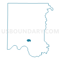
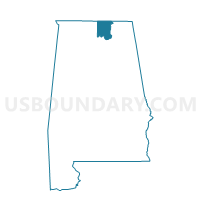
Weatherly Heights Bapt Church, Madison County, Alabama
About
Outline

Summary
| Unique Area Identifier | 522353 |
| Name | Weatherly Heights Bapt Church |
| County | Madison County |
| State | Alabama |
| Area (square miles) | 2.61 |
| Land Area (square miles) | 2.61 |
| Water Area (square miles) | 0.00 |
| % of Land Area | 100.00 |
| % of Water Area | 0.00 |
| Latitude of the Internal Point | 34.63642240 |
| Longtitude of the Internal Point | -86.53885630 |
Maps

Graphs
Select a template below for downloading or customizing gragh for Weatherly Heights Bapt Church, Madison County, Alabama


Neighbors
Neighoring Voting District (by Name) Neighboring Voting District on the Map
- Aldersgate United Meth Church, Madison County, AL
- Big Cove Fire Station, Madison County, AL
- Cove United Meth Church, Madison County, AL
- Hillwood Baptist Church, Madison County, AL
- Madison County Nature Trail, Madison County, AL
- Willowbrook Bapt Church, Madison County, AL
Top 10 Neighboring County Subdivision (by Population) Neighboring County Subdivision on the Map
Top 10 Neighboring Place (by Population) Neighboring Place on the Map
Top 10 Neighboring Unified School District (by Population) Neighboring Unified School District on the Map
Top 10 Neighboring State Legislative District Lower Chamber (by Population) Neighboring State Legislative District Lower Chamber on the Map
Top 10 Neighboring State Legislative District Upper Chamber (by Population) Neighboring State Legislative District Upper Chamber on the Map
Top 10 Neighboring 111th Congressional District (by Population) Neighboring 111th Congressional District on the Map
Top 10 Neighboring Census Tract (by Population) Neighboring Census Tract on the Map
- Census Tract 29.21, Madison County, AL (6,224)
- Census Tract 29.11, Madison County, AL (4,535)
- Census Tract 29.22, Madison County, AL (4,387)
- Census Tract 27.21, Madison County, AL (4,039)
- Census Tract 27.22, Madison County, AL (3,074)
- Census Tract 29.12, Madison County, AL (2,466)